
Basics
Home and SearchSite Guide
Brentford Basics
Privacy Policy
Contact
People
FamiliesPhotos of people
Name indexes incl WW1
Memories
Lists, Documents, News
Occupations
Properties
Properties: High StreetProperties: non-High Street
Photos
Maps
1909/10 Valuation Index
Pub Hub
Can You Help?
Seeking...Mystery photos
Roads Off
A-Z listJanet's Research
HistoryBeach's Jam
Nowell Parr
Turner the Artist
Queen Victoria 1840
Brentford Market
80 High Street
Clitherow of Boston House
Four Croxford Brothers
Sources & More
They SaidBooks etc.
Web Links
Next
Site Technology
Author
Home and Search
Not Brentford
Brentford - Market Place to Half Acre circa 1930
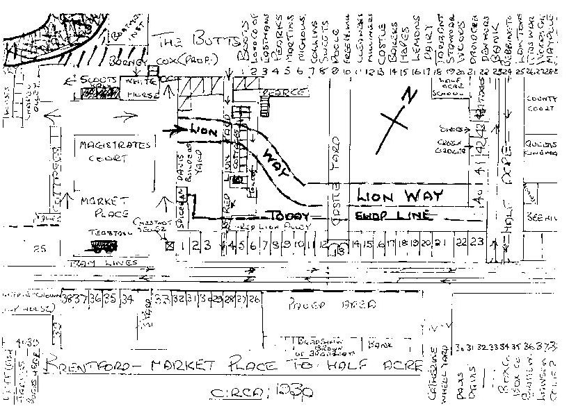 |
Thanks to Mrs Nadine Dunn-Meynell for providing this map, which has been drawn by T.W. Collis. It shows the shops he remembers from around 1930, with an indication of today's road layout (eg Lion Way). A quick check against the 1928 trade directory shows Mr Collis has a good memory! Marked on the map are the tea stall and chestnut seller in the Market Place, the Boatmen's Institute, White Horse, Half Acre School & Queens Cinema. Mr Collis has also included a key to the shops on the map; this is reproduced below in case the image is not clear: Some links to find out more about the area shown and its occupants
|