
Basics
Home and SearchSite Guide
Brentford Basics
Privacy Policy
Contact
People
FamiliesPhotos of people
Name indexes incl WW1
Memories
Lists, Documents, News
Occupations
Properties
Properties: High StreetProperties: non-High Street
Photos
Maps
1909/10 Valuation Index
Pub Hub
Can You Help?
Seeking...Mystery photos
Roads Off
A-Z listJanet's Research
HistoryBeach's Jam
Nowell Parr
Turner the Artist
Queen Victoria 1840
Brentford Market
80 High Street
Clitherow of Boston House
Four Croxford Brothers
Sources & More
They SaidBooks etc.
Web Links
Next
Site Technology
Author
Home and Search
Not Brentford
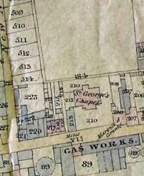
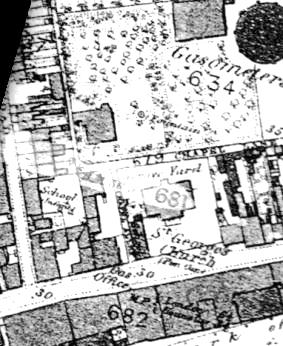
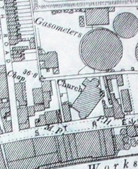
Comparison of Tithe, 1865 and 1894 OS Maps showing St George's Church and environs
 |  |  |
| 1839 Tithe Map | 1865 OS Map | 1894 OS Map |
1839
The 1839 Tithe map shows a school on the corner of North Road, followed by stabling and a yard owned by Sir Felix Booth, then a series of small houses running up to Chapel Alley, followed by Mrs Trimmer's Sunday School (property ref 213).
Building plots are set out on the eastern side of New North Road. Behind St George's Chapel is open ground, and the Marquis of Granby is marked next door to the church.
1865
The land behind the church in the 1865 OS map appears to be gardens with a fountain and a new building has been erected on the western side - this may be Brentford Lodge. The school is now marked a little way up New North Road and is recorded as an infants school. The yard and stabling have been demolished to make way for an entry into a few properties set back a little from the High Street and the Gas Office has replaced two or three of the small houses near Chapel Alley. The gasometers which were on the south side of the High Street have been replaced by three gasometers on the northern side.
1894
By 1894 St George's church has been rebuilt on a different axis and a new gasometer sits behind the church. Some of the properties between Mrs Trimmer's Sunday School and North Road have been altered again.
Links
More about the properties and people who lived here.
Brentford Gas Works by David Shailes.