
Basics
Home and SearchSite Guide
Brentford Basics
Privacy Policy
Contact
People
FamiliesPhotos of people
Name indexes incl WW1
Memories
Lists, Documents, News
Occupations
Properties
Properties: High StreetProperties: non-High Street
Photos
Maps
1909/10 Valuation Index
Pub Hub
Can You Help?
Seeking...Mystery photos
Roads Off
A-Z listJanet's Research
HistoryBeach's Jam
Nowell Parr
Turner the Artist
Queen Victoria 1840
Brentford Market
80 High Street
Clitherow of Boston House
Four Croxford Brothers
Sources & More
They SaidBooks etc.
Web Links
Next
Site Technology
Author
Home and Search
Not Brentford
Postcard showing the fire station, early 1900s
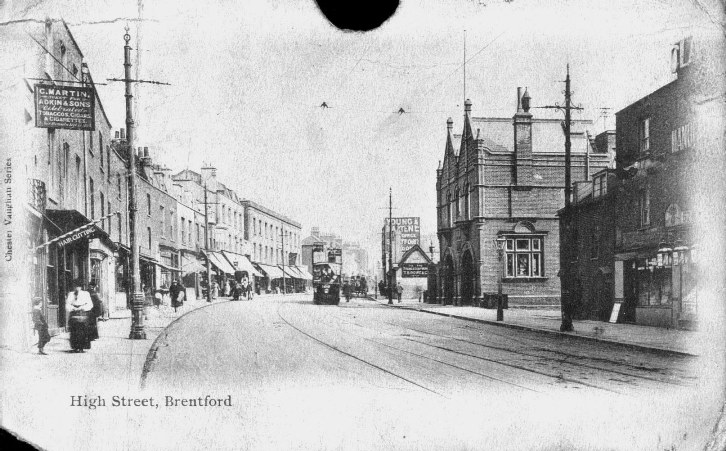 |
Roger Davis provided this image. The fire station is the prominent brick building centre right. It was built in 1897. The shops to the right of the fire station are numbers 54 to 57: the number 57 can just be made out on the rightmost property and was used by Clarnico, confectioners (makers of large caramels covered in pink or white icing, a dentist's nightmare). The single storey building with the gable end to the left of the fire station is the Ferry Lane Almshouses. These were in a 'dangerous state' in 1841 (P). The sign on this wall is for T B Rowe, local soap manufacturer. The shops on the left, on the north side of the High Street start at around no. 276. There is a sign for C. Martin visible and a Charles W Martin, plumber, lived at no. 276 in 1901; by 1911 H J Horton, hairdresser, was at no. 276 (see striped pole); perhaps they shared the property? See details of properties on the right, including the fire station and details of properties on the left |