Basics
Home and SearchSite Guide
Brentford Basics
Privacy Policy
Contact
People
FamiliesPhotos of people
Name indexes incl WW1
Memories
Lists, Documents, News
Occupations
Properties
Properties: High StreetProperties: non-High Street
Photos
Maps
1909/10 Valuation Index
Pub Hub
Can You Help?
Seeking...Mystery photos
Roads Off
A-Z listJanet's Research
HistoryBeach's Jam
Nowell Parr
Turner the Artist
Queen Victoria 1840
Brentford Market
80 High Street
Clitherow of Boston House
Four Croxford Brothers
Sources & More
They SaidBooks etc.
Web Links
Next
Site Technology
Author
Home and Search
Not Brentford
Properties east of Pope's Cross, South Ealing
Judy and Harvey wrote in 2015, sending family photos, including one that shows a milk cart: (Frederick Bovingdon, Southfield Farm, South Ealing).
Research into the location of Southfield Farm was revisited in March 2023 and the following notes have some information about its neighbour, Goodenough House, too.
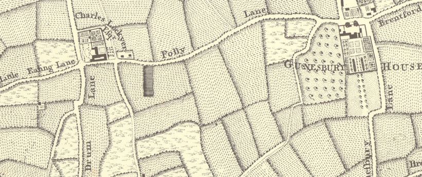
In the 1911 census Robert Dredge, dairyman, was recorded at "Southfields", Ealing. The Genealogist's mapping facility shows Dredge's home was near a rectangular fish pond, on the south side of Pope's Lane, not far east of Pope's Cross. So this formed the starting point - a distinctive rectangular pond south of Pope's Lane.
The findings are presented in chronological order, more-or-less, with diversions to follow up occupants.
Eighteenth century
 |
Nineteenth century
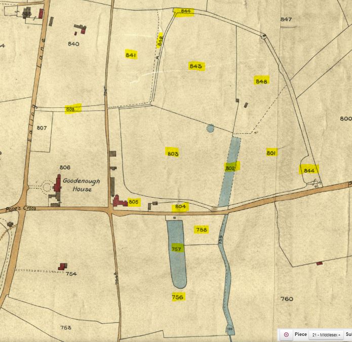 |
Goodenough House, with just over 6 acres around it, was owned by Mrs Roberts under lease from the Bishop of London, occupier Mrs Davies. In the Ealing censuses of 1801 and 1811 the Reverend William Goodenough was the head of the first household in Ealing, followed by Edward Roberts. They may have been neighbours.
In 1840, to the east of Goodenough House, was James Atkinson's farm, split by Pope's Lane, with approximately 11 acres of land including the rectangular pond on the south side of the road, and 31 acres on the north side. He farmed around 42 acres of land, all but 4 acres meadow, and owned 38 acres; he leased field '841' from the Bishop of London. His 'house, garden and appurtenances' were near Popes Lane in the rectangular area marked in Rocque's map. Other buildings nearby were presumably barns or sheds and not occupied.
The 1841 census records James Atkinson in Ealing; properties on the same census page were either 'near the church' or 'north side Gunnersbury Lane'. Atkinson was 55, independent and his household included Elizabeth 35, daughters Clara 11, Emma 8 and James junior, 6 plus a governess and servants. James and his wife were not born in Middlesex.
10 July 1841 the Morning Post reported:
FIRE AT EALING: a fire in the rick yard of 'Mr James Atkinson, perfumer of Old Bond Street, who also has a residence between Little Ealing and Gunnersbury. Two ricks are entirely consumed, and Mr Atkinson's loss is estimated at nearly £200'. The Old Brentford fire engine attended but 'the leathern hose ... was cut in two places ... by some person who has for the present escaped undetected.' This was 'an act of some incendiary'. The report mentions 'numerous' similar incidents in Ealing in the last three to four years.
In 1851 the Atkinson household consisted of James, 69, perfumer employing 12 men, born Hayton, Cumberland; his wife Elizabeth, 41, born Newton Devon; and two daughters Clare 20 and Emma 17, both born in St Pancras, London. James junior was not at home. The family had six servants.
Next was Goodenough House School, occupied by George M Gilbert, 46, schoolmaster, born Gosport, Hants and his family: wife Rose R, 32, and eight children aged 2 months to 22: a 'daughter-in-law' Rose M Pocock, 13, was probably from Rose's first marriage, and elder children from George's first marriage. They had three visitors, a servant and 42 boy pupils, most age 9 to 14. Following the boys were six female servants. Their recording at the end may mean they were on the same floor or wing as the pupils.
James Atkinson senior died two years later, the London Evening Standard 30 June 1853 carried a death notice:
On the 27th inst., James Atkinson Esq., of Village Park, Ealing, and Old Bond-street, aged 71.
He was buried at St Mary's, Ealing on 2 July (Parish register, Ancestry).
The Atkinson perfumery business still operates today (2023), see links for more detail. Key points: he had a pet bear; he moved his perfumery to 24 Old Bond Street in 1832.
James Atkinson prepared his will on 17 June 1853; he was 'of no. 24 Old Bond Street ... and of Village Park Ealing'. He left 'all my freehold and leasehold messuages or tenements and lands called Village Park situate at Ealing' to his wife Elizabeth.
In 1861 the Village Park household was recorded between New Farm and Goodenough House, both on the north side of Pope's Lane. Village Park was occupied by James Atkinson, 25, unmarried landed proprietor, born London, Middlesex. Frank H W J Peacock, born Northumberland, was visiting, and there were four servants including a butler and a 'tiger': an archaic term for a servant such as a groom or page.
Later James joined the army, married and moved to London; in 1871 he lived in Marylebone and was 'Captain of Militia'. He died at his London residence in 1891. The Kentish Gazette 3 February 1891 reported:
The deceased was the only son of the late Mr J Atkinson, of Village Park, Ealing, Middlesex. He served for over 20 years in the Queen's 3rd Battalion Royal West Surrey Regiment, and retired as a Major only a few years ago.
Atkinson is commemorated in a stained glass window on the north side of St Mary's Church, Ealing, Findmypast has a photo (Middlesex Monumental Inscriptions).
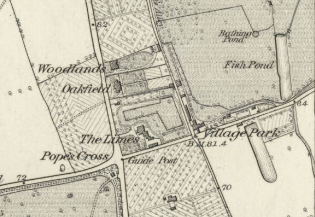 |
In the 1871 census Village Park (address Gunnersbury Lane) had new occupants: Bushell King, 52, annuitant, and his wife Agnes, 59, plus four servants. In 1872, 1874 and 1875 King was recorded as an occupying tenant of Village Park, so ownership may have remained with the Atkinson family.
By 1881 the Kings had moved to Tyler's Green Wycombe, Buckinghamshire and Village Park, recorded after Manor House, Gunnersbury, was occupied by an all-female household: Jane E Mead, 50, her daughters Anne F 18, Florence S 13 and Lily A 11, plus servants Sarah R Rowe 19 and Jane Beard 21. Her younger daughters' births were registered at Hendon in 1868 amd 1870, their mother was formerly named Smith.
Middlesex County Times 18 April 1891 carried an advertisement:
GENTLEMAN wishes to recommend GROOM-COACHMAN, understands horses; can ride and drive well; single, age 26; height 5ft 8in; good character; abstainer - "W.A." Village Park, South Ealing, W
"W.A." could be a red herring, as the 1891 census shows Village Park occupied by Harry B Baker, 39, provision merchant, his wife Matilda A, 41, six children neatly ordered boy, girl, boy etc, father-in-law Charles T Stamper 80 retired carriage painter, mother Mary M Bray 78 Honiton lace maker, four servants and governess Helen A Bull, 26, a certificated teacher: 15 in total. Recorded at the same address, but separated by a line, William Lamble, gardener, his wife Ellen and two sons. The dividing line usually indicates residence under the same roof as the Bakers, but perhaps the Lambles were in an adjoining cottage.
The sequence of recording in the 1891 census:
address Ealing Road South: Twynham (shown on the map below), Garden Cottage, Cemetery Lodge, Isolation Hospital;
address Gunnersbury Lane: "Village Park" (Baker), Village Park (Lamble), Southfield Stables, "New Farm", Ditto Cottage, "The Cottage", Farm Cottage, The Manor House.
Southfield Stables is the first indication of a property with the name "Southfield". The occupants were Charles Clifton, coachman ('groom' added by enumerator) and his wife.
The owner of Southfield Stables was Alexander John George Waterhouse, who died in 1892 leaving a will:
Alexander John George Waterhouse of Southfield Stables South Ealing and of 6 Hyde Park Mansions ... died 30 Jun 1892 Probate London 11 July ... £20,006 4s 11d.
He was only 33 at death and was buried in a grave for two in the consecrated area of nearby Ealing and Old Brentford Cemetery. There is no record of a second burial here (Ancestry: England & Scotland, Select Cemetery Registers, 1800-2016).
Alexander Waterhouse was fined for 'riding furiously', in Rotten Row, Hyde Park in early 1890, and was of Hyde Park mansions at the time, so it seems likely Southfield Stables was his country retreat. He died at 'South Fields Stables' on 30 June 1892 and was the second son of Alfred Waterhouse, according to a death notice, Bedfordshire Mercury, 9 July 1892. I have not found him in the 1881 or 1891 census; he remains a shadowy figure.
 |
The Islington Gazette 15 March 1897 described the wedding of Mr Hugh Plaistowe, third son of Mr W J Plaistowe, of Southfield, Ealing and Kings' Cross, to Miss Mary Macdonald at the Camden Road Presbyterian Church.
Wording suggests Southfield was the Plaistowes' second home.
The Queen 12 June 1897, aimed at ladies, reported
A visit to Southfield Paddocks
Messrs Green have gone a step further and set up a multum in parvo in the way of paddocks. Now, ladies in search of park hacks, etc, will find, close to town, and in a convenient situation for spending an hour or so, an opportunity of choosing a mount, or a good cob for driving, from among the number of fine horses that are being continually broken in and trained on the Southfield Paddocks.'
The above is an extract from a longer piece.
Later in 1897 the Uxbridge & W. Drayton Gazette 17 July reported (at length) on the Horse Shows at Greenford Green. R Green's horse Prince came third in the single-harness horse over 14.2 hands class. His owner was of Crawford Street London and Southfield Paddocks, South Ealing.
Robert Green, jobmaster, Southfield Paddocks, Pope's Lane, was recorded in Kelly's Directory of Middlesex, 1899: in additiona to the paddocks, there must have been stablling and premises in which to greet the ladies and sort out their needs.
Twentieth century
The sequence in the 1901 census:
South Ealing Road: from the north down to the Lodge for Ealing Sewage Works
Popes Lane: Village Park, Southfield Stables, New Farm, Cottage for, Isolation Hospital, Lodge for, Gunnersbury the Cottage.
With a handful of properties to record it seems the census enumerator covered both sides of Pope's Lane in one sweep.
The Baker family remained at Village Park in 1901, a household of 14 including a lady's companion and laundry woman. The Bakers later suffered a setback: Barking, East Ham & Ilford Advertiser, Upton Park and Dagenham Gazette, 5 January 1907, reported
Harry Bray Baker, trading as the County Refreshment Company, Claverhambury, Waltham Abbey and Nottingham, dairy farmer and restaurant proprietor, has been adjudicated a bankrupt.
Perhaps as a consequence the Bakers were in Bromley, Kent in 1911. Three children were still at home and all had the middle name 'Bray'; it seems their father took the name Baker after marrying as 'Bray'. Harry's occupation: Director of Public Company, line of busines 'temperance caterer'. Son Percy was a market gardener and daughter May was an art student. Harry Bray Baker died in 1923, at which point he was of Manor House Farm, Wormley, Hertfordshire. Probate was granted to Harry Bray Baker, banker's clerk, effects £405.
Meanwhile, in 1901 Southfield Stables was occupied by David Ness, coach builder, age 57, born Aberdeen, his wife Josephine, 47 born Marylebone and their five children, ages 20 to 38, including May, 38, art embroiderer. Ness was an employer and it is possible he worked from Southfield Stables. The National Archives has record of a 21-year lease involving Patrick Ness and David Ness, 3 Long Acre, coach builders, dated 1875. By 1911 David Ness and his wife had moved to Fairlight, Sussex and he had 'no occupation' - he had retired. The couple later moved to Hastings, where David died in 1926 and Josephine in 1933.
There is no reference to Robert Green or Southfield Paddocks in 1901; the Paddocks may not have had a live-in caretaker.
London Evening Standard 19 March 1904, under heading RECEIVING ORDERS:
Green, Robert, 146 Portsdown Road, Maidavale, late of 28 and 29 Crawford Street, 1 and 5 Thornton Place, Baker Street and Southfield Paddock, Ealing, W., manager to a jobmaster formerly florist, March 14.
Green's business had failed and bankruptcy proceedings were underway.
In 1907 Middlesex County Times 13 April carried a notice placed by the Chief Registrar of Friendly Societies cancelling the registry of the SOUTH EALING DEMOCRATIC WORKING MEN'S CLUB, held at Southfield Paddock, Pope's Lane.
Southfield Paddock apparently was not a residence at the time.
The 1909 electoral register for Grange Ward Ealing shows Robert Dredge, Southfields, Pope's lane, his former address 107 Seaford Road.
Between 1901 and 1910 the part of Pope's Lane between South Ealing Road and Village Park was filled with 50 new terraced homes, numbers 1 to 24 on the south side and 25 to 50 on the north side, occupying the site of Twynham, previously The Limes, prior to that Gooedenough House. There are news items from 1903 that refer to various Pope's Lane addresses in the 1 to 50 range so some had been built by then. The properties are recorded in the Lloyd George Survey of 1910; they were on plots around 85 feet deep, frontage around 16 feet.
After the Pope's Lane properties, the survey records Village Park, ref. 7018: an old brick built house on three floors, timber built stable for four horses harness room with loft over, cottage with 3 rooms large washhouse. Small timber built and tiled stable and shed. Brick built and tiled coachhouse. The site was 4 acres 1 rood and 15 perch of land; it was owned by Leopold de Rothschild and occupied by Lady Elizabeth Seymour.
Next was land owned by Rothschild, ref. 7019, 31a 1r 29p, tenant A J Robbins: land used for market gardens with small woodland, part orchard.
A cottage followed, ref. 7020, details included with Southfields 7021: large brick built and tiled building with clock turret. Top floor: 2 rooms and loft; first floor: 8 rooms and bathroom with WC. Ground floor: 3 stables for 2 horses each, 1 stable for 7 cows, 1 stable for 6 cows. Coachhouse, dairy & 2 rooms. Lodge with 2 rooms, scullery and WC. Meadow land in rear used for sport. In all 9a 2r 9p.
Ref. 7022 was 15a 1r 1p of land , occupier A J Robbins. 7023: land round Lodge, 'included in other returns'. 7024 was recorded as of both New Farm and Village Park, 70a 0r 29p, and owned by Rothschild. Market garden, meadow and pasture land with house containing 9 rooms, bathroom, conservatory, kitchen, scullery. Farm buildings consisting of stables, barns and a timber built cottage.
7025 was more land, 2a 3r 37p, occupier A J Robbins: building land used as market garden. 7026, a cottage included in 7024. More buildings associated with New Farm followed.
In summary, the survey shows the majority of the original Village Park land (38 acres) had been sold by 1910 with only 4¼ acres retained with the property. Its fields south of Pope's Lane, near 11 acres in 1840, had been divided with over 9½ acres attached to Southfields, by then operating as a dairy farm.
The next evidence is from the 1911 census. Village Park (17 rooms) was occupied by Elizabeth Mary Seymour, widow, 58, her two daughters Horatia 30 and Margaret 20, all Living on Private Means, with four female servants. Next, was "Southfields" (8 rooms) where Robert Dredge was the occupant. He and his wife Elizabeth were born in Marston, Somerset and their daughter Edith, 26, in Ealing. Dredge was 59 and his wife 64. They were followed by Rupert C Wylde at The Rosary (9 rooms). Wylde was a manager of a wholesale clothing business, he was born in Leeds, Yorkshire.
The 1913 electoral register records David Banham at The Lodge, Southfields, followed by Robert Dredge, Southfields. The Lodge may be the two-room lodge referred to in the Lloyd George survey for Southfields.
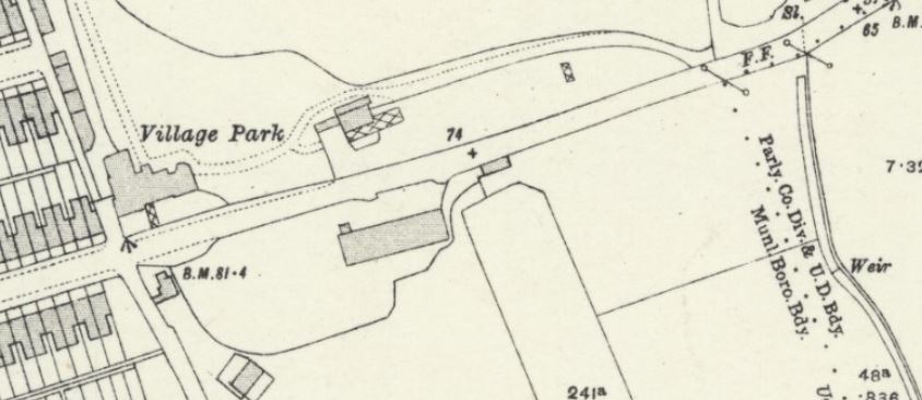 |
Henry Taylor was the occupant of "Southfield Paddock Lodge" in 1914 and is noted in the electoral register of 1915 as resident of "The Lodge, Southfields": two forms of name for the same building. The 1914 citation is from the street directory entry for Pope's lane in the Kelly's Ealing, Hanwell, Brentford & Southall Directory, see the Bovingdon family page for more details and a link to the page in the directory.
The 1921 census recorded Southfield Farm (Bovingdon, dairy farmer) followed by Southfields Lodge. This was occupied by Herbert Henry Massey, 26, optical tube maker, who worked for W. Ottway, at the Orion works, Broadway, Ealing. His eldest daughter Joan, age 3 years 6 months, was born in Acton, so he had moved into Southfields Lodge since the start of 1918. Presumably his home had no land, just a garden.
West Middlesex Gazette 17 October 1925, reported the Ealing and Old Brentford Joint Burial Board accepted a tender of £10 per year from Mr W Halse, 46 Cranmer Avenue, Northfields, for renting a piece of ground in Popes Lane adjoining Southfield Farm, the land being planted with fruit trees, an area of about 1 acre 14 poles.
It is a good match to the orchard shown on the map from 1934, below, to the east of Southfield Farm. It is now part of the cemetery.
This is the last reference to Southfield Farm found in the British Newspaper Archive as at 2023.
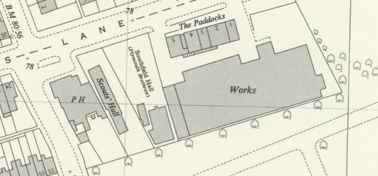
The next item refers to Southfield Hall, which is shown in the next two maps:
British History Online, from G.R.O. Worship Reg. no. 45124, notes 'Brethren met at Dean hall, Williams Rd., Ealing Dean, from 1912 and at Southfield hall, on S. side of Pope's Lane, S. Ealing, from 1928. Both groups survived 1978.'
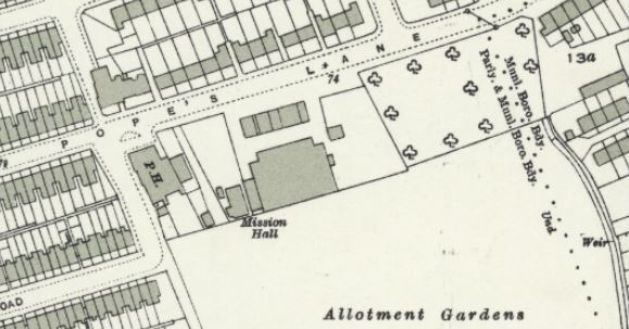 |
On the south side of Pope's Lane there is a pub on the eastern side of Roberts Alley, an un-named building adjoining it, the Mission Hall, then a substantial, un-named building set back, with a terrace of five smaller buildings fronting Pope's Lane. To the east, the orchard, stream and weir survive, but the rectangular pond has gone and to the south allotment gardens occupy former farm land, with an extension to Ealing and Old Brentford Cemetery south of them.
This reference to Southfield Paddocks, Pope's Lane is from 1939 Middlesex County Times 11 November 1939:
PHYLLIS VERNON wishes to inform her clients that she has removed her Surgery for Cats and Dogs to 5 Southfield Paddocks, Pope's Lane, Ealing, W5. Telephone Ealing 4340. Animals boarded in her country cottage.
This is one of the five new-builds fronting Pope's Lane.
The Middlesex County Times 1 May 1943, published a letter from a M E R Jones (about the Red Barn Murder and apprehension of William Corder, witnessed by the writer's grandfather William Jones, age 19, in 1828). The writer states 'the only houses in Popes lane ... from the crossroads to Gunnersbury Park were: South side. Southfield Paddock, just east of the footpath leading to Brentford; north side, Village Park, also just east of the footpath aforesaid, and Robin's Farm, at the corner of what is now Elderberry Road.'
Robin's Farm must be New Farm, which was occupied by Arthur J Robbins in the 1901 census and at the time of the Lloyd George survey; the memory seems to be that of M E R Jones, not his grandfather, and from the early 1900s. The 'footpath leading to Brentford' sounds like Robert's Alley?
 |
Twenty-first century
Google Street View covered this area regularly between July 2008 and September 2022 offering a snapshot of changes over a 14 year period.
Starting from Pope's Cross, numbers 1 to 24 and 25 to 50 Pope's Lane survive: at least some look like the original Edwardian buildings. At the next cross roads to the east the pub on the corner is the West Five Bar, a LGBTQ+ venue founded in 1998.
The Scouts' Hall, marked next to the pub in 1960, remains and has been renamed Jack Girvan Hall. See link below for a history of Ealing Scouts and the Hall, which started out as a WW2 shelter.
The next building was under construction in 2014, occupied 2016: 3 houses and two luxury flats according to the blurb, in a single building. In 2008 there was a patch of grass here and a caravan: the site of the Plymouth Brethren's Mission Hall.
Travis Perkins takes up the next stretch, with a long frontage to Pope's Lane and access to the rear from either side. The building is not modern and may occupy Southfield Paddocks numbers 1 to 5. The OS Maps from 1934 and 1960 show a large building behind, marked as 'Works' in 1960, this must now be the TP yard. Behind this, with access from a little way to the east down Pope's Lane, is Ealing and Old Brentford Cemetery extension dating from 1940. This is where the small orchard was sited.
Some tentative conclusions regarding the location and history of Southfield Farm have been added to Judy and Harvey's page about the Bovingdon family.
There are some loose ends:
- The Rosary is another property not named on maps and appears to be linked to New Farm, which has not been investigated
- the pub which appears on the 1930s OS map may have been renamed and its build date is not known
- a table summarising property names, dates and occupiers/owners could help clarify the text above (and the next time this is picked up will be added)
Links and sources
James Atkinson was not your run-of-the-mill perfumer, having a pet bear: Read more. Wikipedia has information about him and several links.
The West Middlesex Family History Society has recorded the inscriptions at St Mary's Ealing. The inscriptions are on Findmypast and they have produced a plan showing their locations.
The Leicester University Historical Directories website has several Middlesex directories from 1853 to 1914: Pope's Lane, 1914
Parks and Gardens has more about the history of Ealing and Old Brentford Cemetery. A plan of the cemetery drawn in 1999.
National Library of Scotland website for OS maps: read more.
There is a wealth of research into the Lockyer family, whose home is labelled 'Charles Lockyer Esquire', Rocque map of 1746.
Other sources used are subscription sites: The Genealogist (tithe and Lloyd George Survey); Findmypast (British Newspaper Archive, censuses including 1921, electoral registers pre-1932) and Ancestry (censuses, family trees, probate records from 1858 onwards, London electoral registers 1932 onwards).
Page published April 2023