
Basics
Home and SearchSite Guide
Brentford Basics
Privacy Policy
Contact
People
FamiliesPhotos of people
Name indexes incl WW1
Memories
Lists, Documents, News
Occupations
Properties
Properties: High StreetProperties: non-High Street
Photos
Maps
1909/10 Valuation Index
Pub Hub
Can You Help?
Seeking...Mystery photos
Roads Off
A-Z listJanet's Research
HistoryBeach's Jam
Nowell Parr
Turner the Artist
Queen Victoria 1840
Brentford Market
80 High Street
Clitherow of Boston House
Four Croxford Brothers
Sources & More
They SaidBooks etc.
Web Links
Next
Site Technology
Author
Home and Search
Not Brentford
1909/10 Valuation Records, also known as the Lloyd George Survey
This note was updated in 2023 to add more context and to reflect availability of records online.
The valuation records provide a description of each property at around 1910 - 1915, particularly useful if your family lived in a house that has since been demolished and does not feature in the local history book photos. I am grateful to Mark Herber for describing these records in his excellent Ancestral Trails.
The original records are held at The National Archives, Kew and survive for most of the UK. A major step forward in the 2020s is the availability of records for some counties, including Middlesex, online, thanks to The Genealogist website (£).
I have included some information from these records in the Property pages, but ofen have more material: if you are interested in a particular property then please contact me, I will email what I have.
The following notes give some more information about
- the Finance Act leading to the Valuation
- the plans used in the Valuation
- the Field Books which contain the property descriptions
- some of the more colourful descriptions
- an original Field Book entry
- list of the Valuation Books which cover the High Street properties
The Finance Act
Wikipedia: The 1909/1910 People's Budget was a proposal of the Liberal government that introduced unprecedented taxes on the lands and incomes of Britain's wealthy to fund new social welfare programmes. It passed the House of Commons in 1909 but was blocked by the House of Lords for a year and became law in April 1910. It was championed by the Chancellor of the Exchequer, David Lloyd George, and his young ally Winston Churchill, who was then President of the Board of Trade and a fellow Liberal.
As a consequence it is often referred to as the Lloyd George Survey.
The Finance (1909-1910) Act provided for the levy and collection of a duty on the increase in value of all land in the UK. The Act required each district to value each plot of land and this work was completed by the Autumn of 1915.
The exercise resulted in the creation of a number of records; two key ones have been used in this website:
- Plans based on the 1894 OS Maps
- Field Books
Other records were also created, see for a more detailed information leaflet from The National Archives.
Plans based on the 1894 OS Maps
1894 Ordnance Survey maps were used, each plot of land being given a unique (to the map) reference number which was written on the map. Brentford High Street is split across two maps, one covering the western section, a second covers the eastern end and Kew.
The western section is on map reference XX.4 and has TNA ref IR 121/13/5.
The eastern section is on a map reference XX1.1. I have not been able to find this map at TNA: I have found a map covering the same area but with the Surrey property references added, not those for Brentford which is in Middlesex. Fortunately it is not
Field Books
One or more field books was compiled for each district: Old Brentford has 36 field books, New Brentford has 6, each containing details of up to 100 plots. If you are searching for details of a particular road, by finding it on the annotated OS Map you can tell which property reference numbers you are interested in and use TNA indexes to order the relevant field books.
Each field book is about A5 size and each plot is described using 4 pre-printed pages. The level of detail varies from one valuer to another and includes
- usually the owner's name and address (see surname index to all owners of High Street properties, extracted from the field books)
- often the name of the occupier
- usually the frontage to the High Street in feet and inches
- usually a description of the construction of the property
- usually a summary of the number and types of room on each floor
- always the valuation (see summary by house number of all High Street properties, extracted from the field books)
- sometimes a plan showing all the buildings on a plot
- sometimes an assessment of the age of the property, although this is often given as 'old' or 'very old'
- sometimes the date of the valuation, 1910 to 1915
- often an assessment of the condition of the property such as 'fair repair'
Some of the more colourful descriptions
The character of the valuer was often apparent through his write-ups. Some entries are clearly written and contain much detail; others look casually and quickly turned out; in some cases the description suggests the valuer had had enough of the exercise.
A few examples:
- Large square brick and slate building...formerly a chapel. Balcony round entire building inside...Approached from the High Street only by a passage (no. 234A)
- bakehouse at rear with 9 bushel oven (no. 281)
- vaults run under the gardens of 308 - 312 (High Street) inclusive and used by brewers - with exit in Lee Yard (no. 312)
- small shop with iron spiral staircase to first floor being only way up (no. 218)
- consisting of 2 small blocks of rooms, each block containing on the top floor 2 rooms and on the ground floor 2 rooms, the ground floor rooms have a coal cupboard each (St George;s Almshouses at no. 6)
- as a wharf considerable dredging would have to be done & repairs carried out as only shallow draught & to go under a low bridge to get to canal (no. 189)
- premises pulled down for rebuilding, understand they were condemned by Local Authorities some months back (no. 177)
- cellar (often waterlogged) (no. 173)
- has bath on first floor which however has no water service (no. 153)
- disused cemetery, completely buried in. Old brick mortuary chapel standing (rear of St Lawrence's churchyard)
- Ruinous washhouse with yard beyond & WC...Empty & dilapidated. Condemned. (no. 135)
- old and dilapidated and about to be demolished (no. 406)
- expended on premises since death of owner on 26/9/1910: £150 (no. 345)
- probably about 300 years old (no. 334)
- ground floor: dirty old shop, parlour, workshop, washhouse (no. 329)
- the grounds have a long frontage to the river... there is a detached building originally used as a laundry (St George's Vicarage at no. 28)
Example from a Field Book
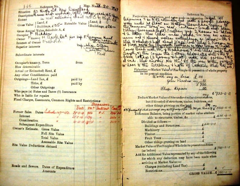 Click image for larger version. These are the first two pages for 93 High Street and show one of the more descriptive and complete entries. The original Field Book has TNA reference IR 58/40143. |
The Field Books which cover High Street properties
I have created a summary by house number of all High Street properties, extracted from the field books.
| House No. From | To | Assessment No. From | To | TNA Ref: IR 58/ |
|---|---|---|---|---|
| 1 | 22 | 3087 | 3100 | 40179 |
| 23 | 64 | 3101 | 3200 | 40180 |
| 65 | 85 | 3201 | 3232 | 40181 |
| 86 | 136 | 153 | 101 | 40143 |
| 137 | 223 | 100 | 15 | 40142 |
| 227 | 246 | 1172 | 1191 | 40159 |
| 247 | 309 | 1206 | 1300 | 40160 |
| 310 | 318 | 1301 | 1312 | 40161 |
| 319 | 320 | 2399 | 2400 | 40171 |
| 321 | 355 | 2401 | 2434 | 40172 |
| 356 | 384 | 2609 | 2699 | 40174 |
| 385 | 411 | 2703 | 2730 | 40175 |
Published 2008; last updated April 2023