Basics
Home and SearchSite Guide
Brentford Basics
Privacy Policy
Contact
People
FamiliesPhotos of people
Name indexes incl WW1
Memories
Lists, Documents, News
Occupations
Properties
Properties: High StreetProperties: non-High Street
Photos
Maps
1909/10 Valuation Index
Pub Hub
Can You Help?
Seeking...Mystery photos
Roads Off
A-Z listJanet's Research
HistoryBeach's Jam
Nowell Parr
Turner the Artist
Queen Victoria 1840
Brentford Market
80 High Street
Clitherow of Boston House
Four Croxford Brothers
Sources & More
They SaidBooks etc.
Web Links
Next
Site Technology
Author
Home and Search
Not Brentford
Goat Wharf
Goat Wharf is the name of both the wharf on the Thames and the road running down to it between numbers 50 and 51 High Street.
Origins
Some yards, alleys and roads are named after a nearby public house, for example Catherine Wheel Yard and Drum Lane. Although Brentford had a Goat Inn in the early 1700s, it was on Ferry Lane, the next road west of Goat Wharf. I suspect a link; perhaps Goat Wharf on the Thames took its name from the pub, then later the road leading to the wharf took its name from it.
The following items from the British Newspaper Archive are some of the earliest references found, as at 2023.
Middlesex Chronicle 7 April 1877, included a report from Mr Figg, Surveyor:
...The Committee appointed to inspect the paving met on the 24th ult and recommended the following works to be done:- The pitching of Mr Carpenter's gateway to be taken up and relaid with new granite; the pitching at Goat Wharf to be taken up and relaid, part to be new granite ...
Acton Gazette 25 January 1879, reported:
GOAT WHARF
Mr R Atkin, manager of the Hope Lighterage Company, wrote, calling the attention of the Board to the state of the thoroughfare leading to Goat Wharf and the river, from the main street.
Some discussion arose as to whether the road could be considered a public one, but the matter was ultimately referred to the Works Commitee.
Acton Gazette 20 March 1886
CARRIAGE WAYS
It was agreed on the Works Committee's recommendation ... to give Mr Voysey a crossing at Goat Wharf nursey.
Middlesex Independent 7 April 1886 reported that the kerbing had been lowered opposite Goat Wharf nursery for Mr Voysey.
Maps
Four maps chart the development of Goat Wharf from 1840 to 1961.
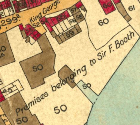 | The tithe record, 13 June 1840, shows a gap between High Street properties with tithe references 53 (four houses and premises) and ref. 54 (public house, label George IV, and premises), all owned by Thomas Harrington, maltster and coal merchant. There is no clearly defined road to the wharf as as there is in later maps. |
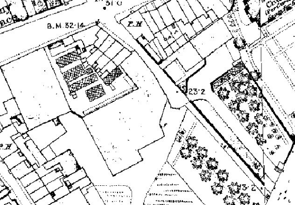 | The Ordance Survey 1:10560 map from a survey of 1867 shows a pub on the eastern corner of Goat Wharf, (un-named) Thames Bank House then premises with a long frontage to the road. On the western side, adjoining properties run from the corner (51 High Street), with a terrace of four followed by a large un-named building along Goat Wharf. There were orchards on either side of Goat Wharf on the approach to the Thames. Perhaps the location of Goat Wharf Nursery, referred to in the 1886 news items above? |
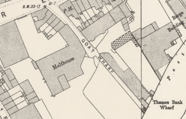 | The 25" to mile OS map from a survey of 1893 gives a clearer impression of buildings vs space and names the large building shown in 1867 as a malthouse. Thames Bank House has been extended and now has two bays, recognisable in the photo (link below). The wharf was named Thames Bank , not Goat Wharf, on this map. |
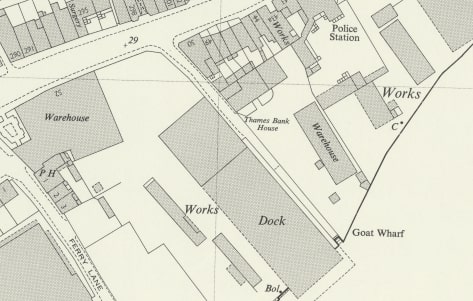 | By the time the Ordnance Survey revised their map of this area in 1960 the cottages and 51 High Street had been cleared. The map labels Thames Bank House, home of William & Bridget Payne from around 1912, a base for Clements, Knowling & Co. Limited, tug owners in 1914 and home of James Clements in 1915. |
Numbering and occupants
Five households were recorded in the 1881 census, headed by
- Charles Sansum, lighterman
- Robert Arnold, gardener
- Charles Cooper, carman
- Thomas Clevley (Clewely?), waterman
- Richard Rapkin, managing lighterman
In 1901 the Goat Wharf properties were numbered 1 to 5:
- Charles Sansom, lighterman
- David Salmon, maltster
- Thomas Cox, malt maker
- Harry J Salmon, maltster
Thames Villa was recorded after no. 4: John H Mulford ?, general foreman wharf
also Wilfred Chapple, steam crane driver - William Bowers, foreman maltman
In 1911 numbers 1 to 4 Goat Wharf were recorded thn Thames Bank House; total in each household in brackets:
- Walter Thomas Morris Hoare, foreman (5), 4 rooms
- James Farrington, coal porter (8), 4 rooms
- Ernest Dutton, carman (4), 4 rooms
- Harry Jesse Salmon, corn porter (6), 4 room cottage
Thames Bank House, James Clements, managing director Clements Knowling & Co Ltd (9), 7 rooms
In 1921
- Arthur Charles Hollocks, general labourer for L.U.E. Tramway (5), 4 rooms
- James Farrington, general labourer for J Lyons and Co (7), 4 rooms
- Ernest Dutton, carman, out of work, last employer Clements Knowling (5), 4 rooms
- Harry Jesse Salmon, corn porter for Jupp & Sons, corn merchants (5), 4 rooms
Thames Bank House, William Alfred Payne, foreman, contracting dept of Clements Knowling & Co Ltd (8), 6 rooms
Kelly's 1938 trade directory records the following people and properties on Goat Wharf:
East Side
Carey, Harold George (Thames Bank House)
Clements, Knowling & Co. Ltd, contractors** (see below)
River Lighterage Co. Ltd., tug owners
West Side
1 Hollocks, Arthur Chas.
2 Farrington, James
3 Dutton, Ernest
4 Monk, Henry
Numbers 1 to 4 must be the properties shown above.
** Wiltshire & Swindon Record Office holds an agreement dated 1907 between James Clements & George Knowling (of Goat Wharf, trading as Clements Knowling & Co) and the Great Western Railway for tenancy of stables at High Street Brentford. James Clements was also the deputy superintendent of the Fire Brigade in 1913 and Charter Mayor of Brentford & Chiswick.
Photos/Ephemera/Maps
Three views from the High Street, various dates.
View of the river end of things, 1974 and barges moored there, 1976.
More information about the George IV and properties to its east; numbers 51 to 60 High Street
Victory party at Thames Bank House, 1945
Old Brentford tithe map shows the George IV and Goat Wharf, a greater area than above
William & Bridget Payne and James Clements, two families who lived at Thames Bank House in the early 1900s
Published April 2023