Basics
Home and SearchSite Guide
Brentford Basics
Privacy Policy
Contact
People
FamiliesPhotos of people
Name indexes incl WW1
Memories
Lists, Documents, News
Occupations
Properties
Properties: High StreetProperties: non-High Street
Photos
Maps
1909/10 Valuation Index
Pub Hub
Can You Help?
Seeking...Mystery photos
Roads Off
A-Z listJanet's Research
HistoryBeach's Jam
Nowell Parr
Turner the Artist
Queen Victoria 1840
Brentford Market
80 High Street
Clitherow of Boston House
Four Croxford Brothers
Sources & More
They SaidBooks etc.
Web Links
Next
Site Technology
Author
Home and Search
Not Brentford
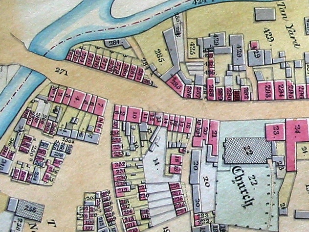
Tithe Map of western part of New Brentford, 1838
This image is reproduced courtesy of Corporation of London, London Metropolitan Archives
 |
The property numbers on the map are those used in the tithe apportionment (starting T below) and are followed by "/" and the house numbers allocated in 1876, eg (T272 = 159 High Street)
On the northern side of the High Street, starting from Brentford Bridge and working eastwards:
- (T272 - T283 / 159 - 170): terrace running up to Brentford Bridge; details of rebuilding in this area between 1826 and 1838
- (T285 / 171, 172): Durham Wharf, numbered as part of High Street
- (T286 - T287 / 173 - 174): two properties running up to Ram Alley, which has three small properties
- (T288 -T292 / 175 - 180): T292 was the Alton Arms, later the Waterman's Arms at 179 High Street; 180 was a 7' wide lock-up shop by 1909/10 and in 1838 is just visible, presumably counted as part of T292; Ansells Passage (later Brent Wharf) follows T292
- (T293 - T297 / 181 - 185): five properties followed by access to the Tanners Yard which is marked on the map running behind the properties; T297 / 185 has access to the river (T297a above) which was commented on in the 1909/10 Valuation
On the southern side of the High Street, working eastwards:
- (T1 - T7 / 158 - 152): T1 & T2 / 158 & 157 set back a little; followed by The Ham
- (T8 - T18 / 151 - 142): originally 11 properties, 10 in 1865, by 1894 nine: see intro to property notes for more details; followed by Church Alley; includes the still standing Six Bells, 149 High Street (T10)
- (T19 - T21 / 141 - 140 ): the tithe maps shows three properties running up to St Lawrence's church including T19 and T19a; these were small properties and may have opened on to and have been counted as part of Church Alley in the census; by 1865 just two properties sit between the church and Church Alley and in 1894 just one, the Black Boys PH
- (T23 / 139): Vicarage, the tithe shows the original site; it was rebuilt further back from High Street between 1865 and 1894 OS Maps, presumably when the church's south aisle was built in 1874
- (T24 / 138): largest house by far in this area; owned by the Ronalds family, seedsmen, who owned land running behind their property and west behind the churchyard, described as 'Nursery Grounds' in the tithe enumeration
More details of the properties and occupants: numbers 127 - 141, 142 - 151, 152 - 158, 159 - 170, 171 - 180.
TopPublished 2005; updated August 2021